/prod01/prodbucket01/media/durham-university/external-location-photography-/city-shots-/82922-1920X290.jpg)
Space junk and satellites: tracking innovation provides new eyes in the sky
An unprecedented expansion of the space sector in recent years has led to a growing number of satellites and debris in Earth’s orbit.
Innovative tracking techniques are now in demand from the defence and commercial sectors to avoid collisions, maintain the health of satellites and improve surveillance capabilities.
This is especially true for the geostationary region (GEO) and medium Earth orbit (MEO) where the majority of surveillance and secure communication satellites are situated. These include those used by the world’s militaries, navigations and communications for ships and planes, weather forecasting and climate monitoring, and banking and telecommunications companies.
Current tracking techniques are expensive and imprecise because they rely on outdated technology and intelligence. A cost-effective, reliable alternative is needed to ensure the sustainable use of space for future generations, as well improvements in space governance.
Academic collaboration
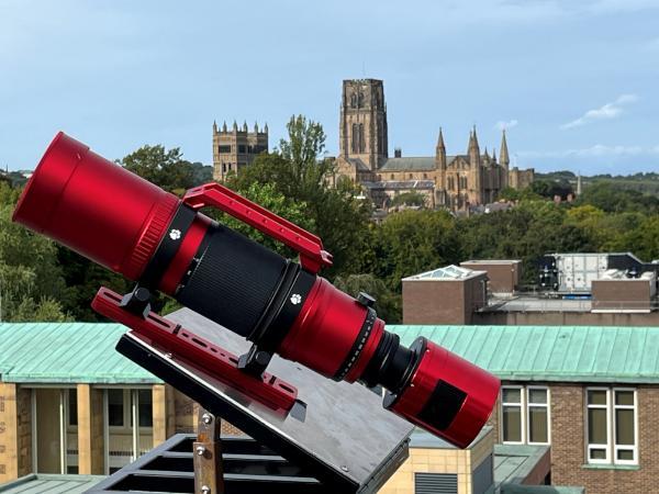
Led by Professor Mark Swinbank and Professor James Osborn, Durham University is drawing on the institution’s rich space heritage to design an innovative solution. The goal is to develop a low-cost, robust instrument capable of monitoring all geostationary objects with verified real-time data analysis to create an accurate catalogue of satellites in orbit.
Results from a proof-of-concept demonstrator impressed UK Space Command – offering UK sovereignty over data, providing a solution to unsustainable current costs for the information, and reducing reliance on a commercial company.
The technology has already been used to track satellites carrying out proximity manoeuvres that have raised concern among governments and the wider space community. Among these is the Russian Luch-Olymp K2 communications satellite that has drawn international attention for approaching and repositioning near other operational spacecraft in geostationary orbit.
Potential impact
Though the UK will be the first to benefit, this innovative solution has the potential to tackle issues of space sustainability and surveillance on a global scale.
The team plans to roll out the system with international partners, enabling testing, calibration and continuous tracking – with the aim of establishing a global network of publicly available information underpinned by full data integrity.
Not only would this offer the world a clear view of objects in space, but it could also act as a deterrent to potential military hostilities.
The system could also provide valuable information to the commercial and defence sectors in the event of a loss of communication with satellites. Insight into the reasons for faults could be crucial for the insurance of satellites worth hundreds of millions of pounds and positioned up to 36,000km away from Earth.
Real-world impact is incredibly important to our researchers and this project is a shining example of how our academic endeavours can make a difference to everyday life. This technology will allow the UK to lead the way in space surveillance, providing homegrown capabilities and reliable data it can share with the rest of the world.
Impact Acceleration Accounts
This project has been funded through Impact Acceleration Accounts (IAAs). These strategic awards from UK Research and Innovation provide funding to research organisations to use creatively for a wide range of impact activities.
IAAs allow research organisations to respond to opportunities in flexible, responsive and creative ways that align with their institutional strategies and opportunities.
Find out more
Find out more about Durham University Space Research Centre (SPARC)